DEEP DIVE

Maritime Asset Protection

MARITIME ASSET PROTECTION

Surface, low altitude and underwater in one — from passive reaction to proactive protection, a round-the-clock intelligent protection and evidence hub for offshore asset owners.

01

CONTEXT

From passive reaction to tri-domain proactive protection

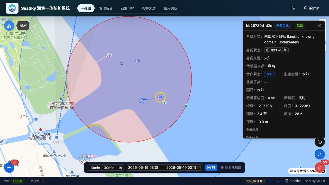
Offshore assets such as wind farms, marine ranches, sea-crossing bridges and submarine cables are high in value and sit in open waters, where protection commonly faces several challenges: radar, AIS, electro-optical and counter-UAV equipment each run in isolation, with no unified targets and no closed alerting loop; threats span the surface (fishing-boat intrusion, night poaching, merchant ships dragging anchor), low altitude (drone intrusion and filming) and underwater (approaching submersibles — nearly a blind zone for traditional means); anomalies rely on manual screen-watching and thresholds, so unseen behaviours slip through; and after-the-fact evidence depends on manual playback and stitching, hardly enough to support claims or accountability.

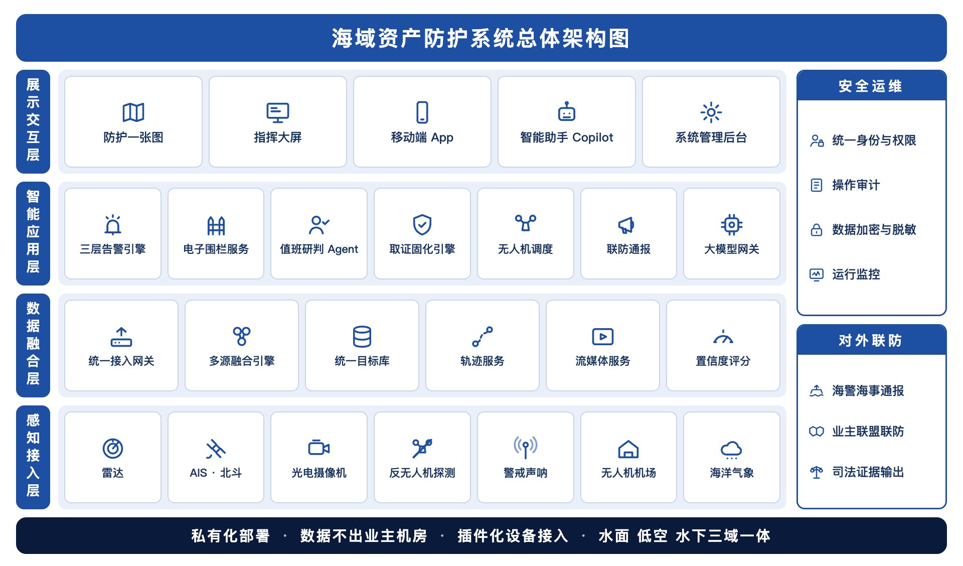
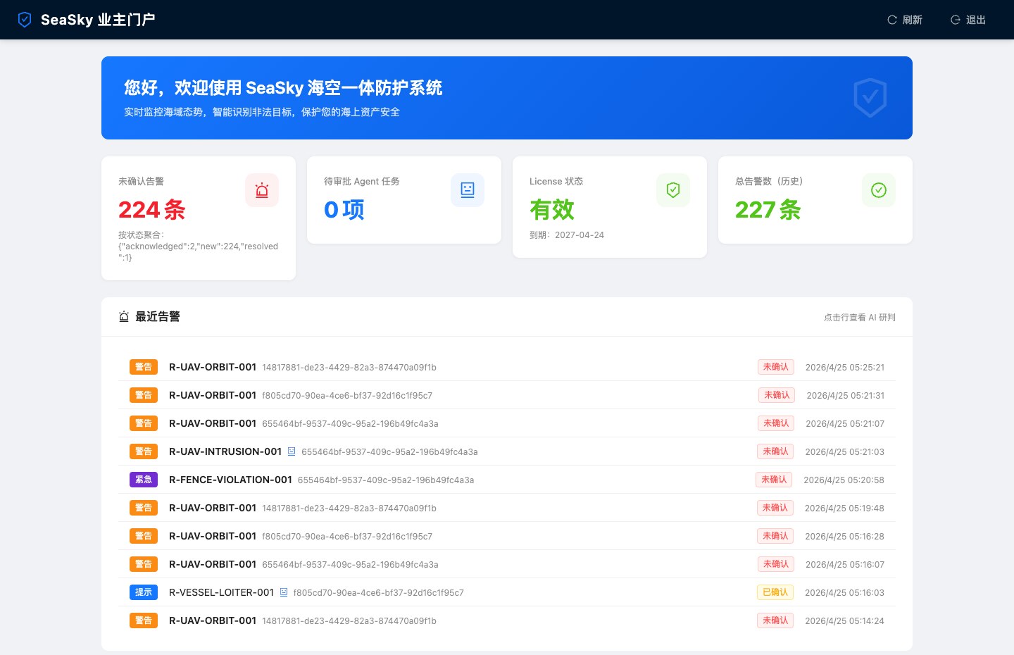
GW-OCEAN builds around multi-source fusion and intelligent alerting, unifying tri-domain sensing onto “one map, one target set, one evidence chain”: anomalies are detected automatically and assessed by severity, UAVs and electro-optical equipment link up for response and evidence capture, and joint-defence notifications can go out to coast guard and maritime authorities — owners keep the initiative of “deterring, evidencing and reporting” firmly in their own hands, upgrading protection from passive reaction to round-the-clock proactive defence.

02

ARCHITECTURE

Layered hub architecture + one protection map

The solution is decoupled into four layers — sensing & access, data fusion, intelligent applications, and interaction & display — with security operations and external joint defence running through all of them. The sensing layer connects radar, AIS, Beidou, electro-optical cameras, counter-UAV detection, sentry sonar and UAV docks over standard protocols, plug-and-play; the fusion layer correlates surface, low-altitude and underwater signals into unique targets with confidence scores; the application layer hosts the layered alerting engine, geo-fencing, UAV dispatch, evidence consolidation and joint-defence notification; the top layer presents everything through one protection map, the command dashboard and the mobile end.

Overall architecture of the maritime asset protection system (schematic)
Maritime asset protection system · overall architecture (schematic)
A

Tri-domain fusion mapFusion Map

Surface vessels, low-altitude drones and underwater targets share one modelling scheme and overlay on one GIS sea chart: geo-fences, live targets, historical tracks and device fields of view render in full, with track playback and end-to-end target traceback.

B

Layered alerting engineLayered Alerting

The rule layer responds within seconds to known threats such as line-crossing, intrusion and loitering; the AI anomaly layer learns normal-behaviour baselines to spot anchor-dragging, loitering and reconnaissance-like tracking; the assessment layer explains why a target is suspicious and suggests how to handle it.

C

Evidence as a serviceEvidence Service

Alerts trigger evidence collection automatically: tracks, video, snapshots and the assessment process are packaged and consolidated with timestamps and hash verification, offline-verifiable — full evidentiary support for claims, accountability and joint-defence reporting.

D

Automatic UAV linkageUAV Linkage

Routine autonomous patrols fly preset routes and hover to capture anomalies automatically; alerts trigger automatic take-off for close-range evidence capture; deterrence actions such as loudspeaker warnings and warning lights are supported, with take-off and landing governed by wind, visibility and other safety guardrails.

E

Geo-fencing & underwater watchUnderwater Watch

Multi-level fences — core, alert, observation — arm by zone and schedule; sentry sonar can be connected to detect and alert on moving underwater targets, closing the underwater blind zone of traditional protection.

F

Agent duty assessment & copilotAI Copilot

AI duty assessment automatically grades each alert with threat level, reasoning and a handling plan, with key actions executed only after human confirmation; ask in one sentence to query targets or get a situation brief. Alert decisions rest on deterministic rules — not on a large model; AI only augments assessment, degrading automatically on failure, safe and controllable.

Maritime asset protection map (UI concept)
Protection map · UI concept
Owner portal of the maritime asset protection system (UI concept)
Owner portal · UI concept (illustrative data)
03

WORKFLOW

Sense — fuse — alert — respond — evidence, in a closed loop

  1. 1

    Tri-domain sensing

    Radar, AIS, Beidou, electro-optical cameras, counter-UAV detection and sentry sonar connect through unified access, covering surface, low altitude and underwater; devices plug in over standard protocols.

  2. 2

    Fusion into unique targets

    Multi-source signals are cross-correlated and deduplicated into unique targets with confidence scores; targets visible on radar without identity broadcast are flagged as non-cooperative automatically.

  3. 3

    Graded alerting & assessment

    The rule engine judges line-crossing and intrusion within seconds; AI anomaly detection spots behaviours such as anchor-dragging and loitering; assessment returns threat level and handling suggestions, pushed by severity to the dashboard and mobile end.

  4. 4

    Linked response & deterrence

    Alerts automatically drive electro-optical lock-on and tracking; UAVs take off on preset plans for close-range follow-shoot evidence, with loudspeaker and light warnings available — key actions confirmed by the duty officer.

  5. 5

    Evidence & joint defence

    Tracks, alerts, assessments, snapshots and recordings settle into a complete event chain, consolidated in one click into an evidence package with hash verification and timestamps; notifications can go to coast guard and maritime authorities, supporting insurance claims.

04

ADVANTAGES

Why GW-OCEAN

Owner-side round-the-clock protection

Not a replacement for law enforcement, but making full use of the owner’s own rights to deter, evidence and report: threats found automatically, handled automatically and logged throughout — asset protection no longer relies on after-the-fact remedies.

Tri-domain, one target set

Surface, low altitude and underwater share one target model and one alerting scheme; vessels, drones and underwater targets render on the same map and chain into the same evidence — eliminating system silos and protection blind zones.

Evidence as a service

Fully automatic from trigger to package: timestamps, hash verification and offline verifiability make evidence complete and credible — solid ground for claims, accountability and reporting.

AI-augmented, rule-grounded

Alert decisions rest on deterministic rules, not on a large model; AI only augments anomaly detection and assessment, degrading automatically on failure with zero alert interruption.

05

TYPICAL SCENARIO

Merchant ship dragging anchor near a cable protection zone · automatic detection and evidence

Typical scenario of maritime asset protection (illustration) Asset Protection · Scenario

A cargo ship slows abnormally at the edge of a submarine-cable protection zone, its track drifting off the fairway — AI anomaly detection recognises the classic anchor-dragging signature and raises an alert, while duty assessment instantly returns the threat level, reasoning and a warning-call suggestion.

The electro-optical camera locks onto the target automatically and a UAV takes off on the preset plan for close-range follow-shoot of the ship’s name and anchor chain; the full track, footage and assessment conclusions consolidate automatically into an evidence package with timestamps and hash verification. After the duty officer confirms, a loudspeaker warning is issued and the maritime authority notified — and the complete evidence chain later supports the cable-damage claim.

  • Anomalies such as anchor-dragging detected automatically — no more manual screen-watching
  • Electro-optical and UAV linkage executes automatically, with close-range evidence logged throughout
  • Evidence packages verify offline, supporting claims, accountability and joint-defence reporting

Need a solution tailored to your sea area?

Whether marine ranching, smart fishing ports, aquaculture, or ocean observation and ecological monitoring, we’d be glad to explore it with you.