DEEP DIVE

Smart Fishing Port Management

SMART FISHING PORT

Multi-source fusion, automatic alerting and electro-optical linkage — from “staring at screens” to “alerts finding people”, a digital-intelligence foundation for fishing-port security and supervision.

01

CONTEXT

From manual watch to automatic detection and real-time linkage

Fishing-port supervision commonly faces several challenges: radar, AIS and video systems present their data in isolation — installed yet unlinked; manual screen-watching is inefficient and alerts slip through; “non-cooperative” vessels with transponders off or spoofed and identity-swapped boats are hard to screen; small fast targets such as speedboats are hard to detect and track, and violations are hard to evidence or trace afterwards.

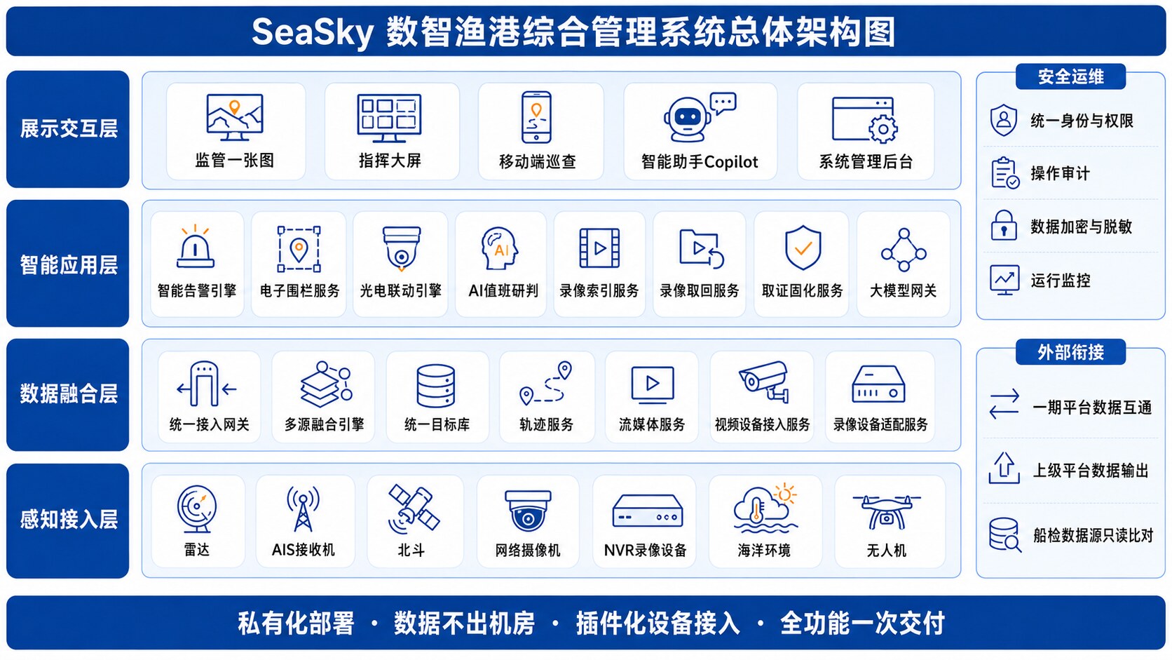
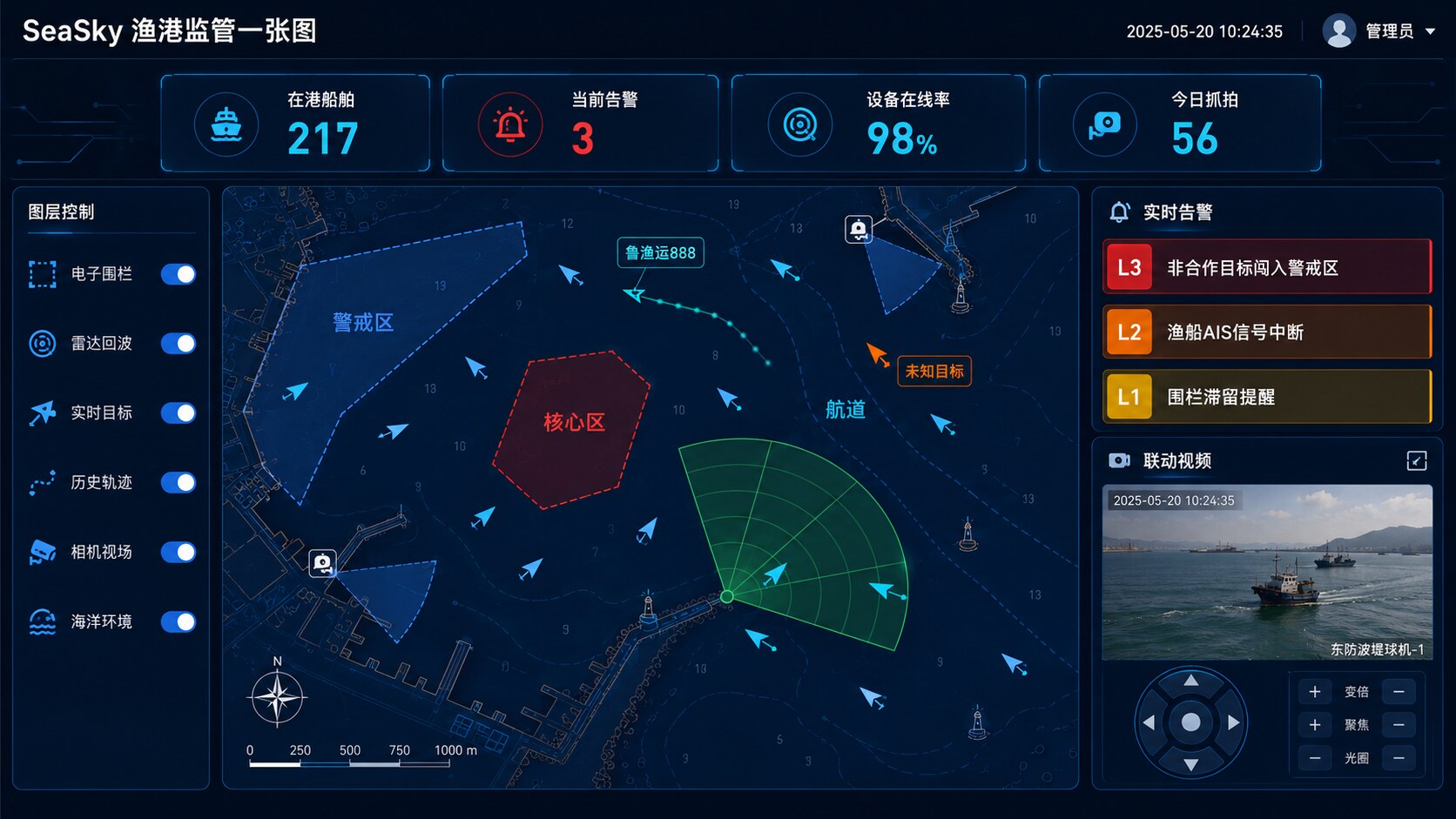
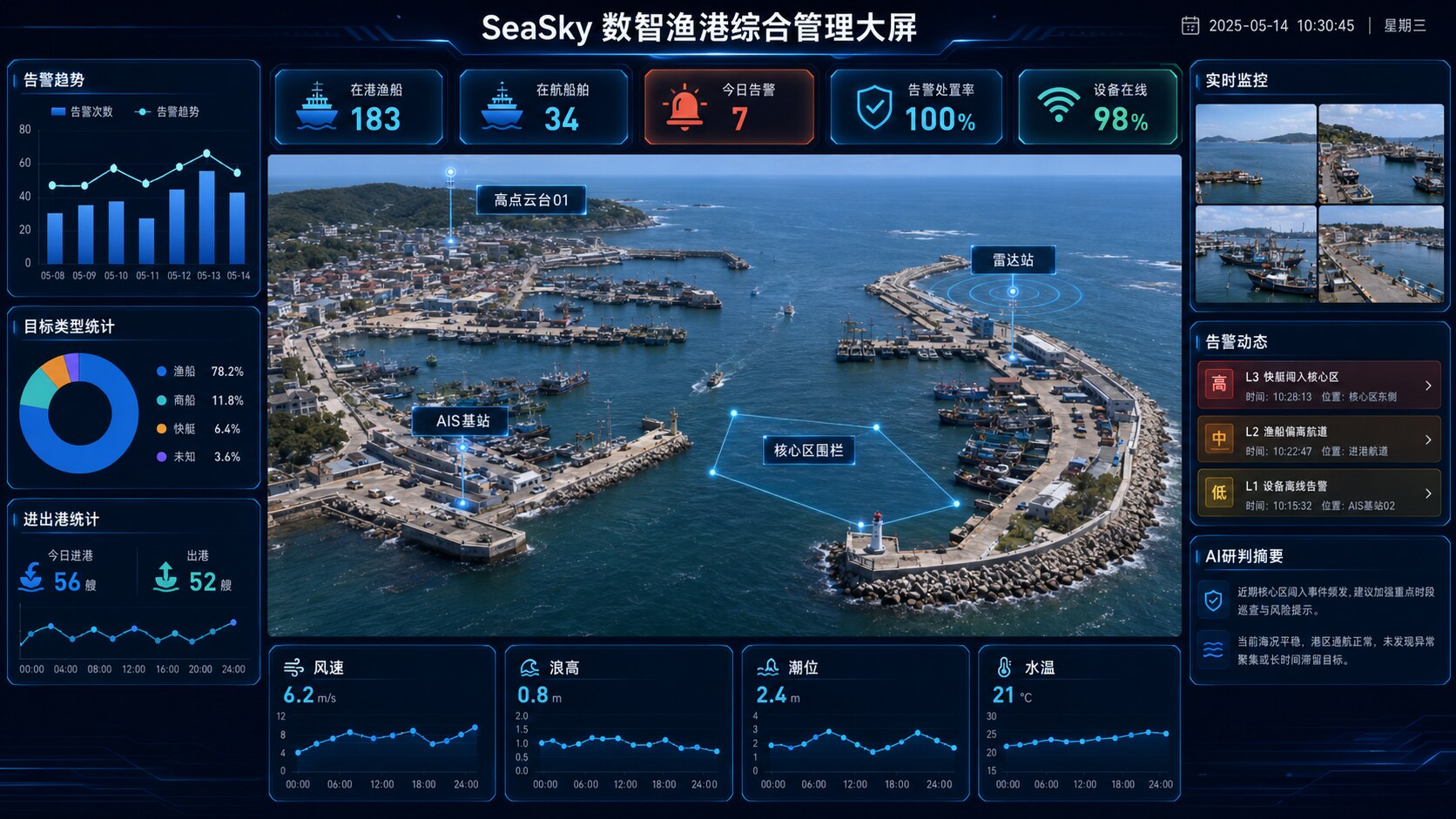
GW-OCEAN builds around multi-source fusion and intelligent alerting, unifying radar, AIS, Beidou and video onto “one map, one target set, one evidence chain”: anomalies are detected automatically and pushed by severity, electro-optical equipment links up for evidence capture automatically — upgrading supervision from passive “patrol the screens, handle afterwards” to proactive “detect automatically, link in real time, capture evidence instantly”.

02

ARCHITECTURE

Four-layer architecture + one supervision map

The solution is decoupled into four layers — sensing & access, data fusion, intelligent applications, and interaction & display — with security and operations running through all of them. The sensing layer connects radar, AIS, Beidou, cameras and existing NVRs over standard protocols, reusing legacy equipment without modification; the fusion layer correlates multi-source signals into unique targets with confidence scores; the application layer hosts geo-fencing, graded alerting, electro-optical linkage and evidence consolidation; the top layer presents everything through one supervision map, the command dashboard and the mobile end.

Overall architecture of the smart fishing-port management system (schematic)
Smart fishing-port management system · overall architecture (schematic)
A

Multi-source fusion mapFusion Map

Radar, AIS, Beidou and video overlay on one GIS sea chart; multi-source signals are correlated and merged into unique targets automatically. Geo-fences, live targets, historical tracks and camera fields of view render in full, with track playback and radar-echo layers.

B

Geo-fencing & auto armingGeo-fencing

Multiple fence classes — core, alert, observation, restricted and channel — with entry, exit and loitering detection plus scheduled auto-arming; draw a zone and it takes effect.

C

Non-cooperative target detectionDark Targets

Targets visible on radar but broadcasting no AIS / Beidou identity raise alerts automatically; clues such as transponders that should be on but are not, mid-voyage shutdowns and identity anomalies are screened automatically.

D

EO linkage & captureEO Linkage

Alerts automatically drive the PTZ camera onto the target: best-camera selection, auto-zoom, continuous following and snapshot capture throughout — no manual operation.

E

Recording index & evidenceEvidence Chain

On-site NVRs record as primary storage with unified platform indexing; event clips are retrieved automatically. Tracks, snapshots, recordings and alert records consolidate into an offline-verifiable evidence package in one click.

F

AI duty assessment & copilotAI Copilot

AI automatically grades each alert with threat level, reasoning and handling suggestions; ask in one sentence to find a vessel, get a situation brief or have an alert explained. Alert decisions rest on deterministic rules — not on a large model; AI only augments assessment, and on failure the system degrades to pure-rule mode with zero alert interruption.

Fishing-port supervision map dashboard (UI concept)
Port supervision map · UI concept
Command dashboard of the smart fishing-port management system (concept)
Command dashboard · concept render
03

WORKFLOW

Sense — fuse — alert — link — evidence, in a closed loop

  1. 1

    Multi-source sensing

    Radar, AIS, Beidou, cameras and marine-weather data connect through unified access; legacy equipment is reused over standard protocols without modification or replacement.

  2. 2

    Fusion into unique targets

    Multi-source signals are cross-correlated and deduplicated into unique targets with confidence scores; targets visible on radar without identity broadcast are flagged as non-cooperative automatically.

  3. 3

    Fence checks & graded alerts

    Geo-fences evaluate entry, exit and loitering in real time; alerts are graded, deduplicated and auto-escalated on timeout, reaching the dashboard and mobile end directly.

  4. 4

    EO linkage & capture

    Alerts automatically drive the PTZ onto the target with auto-zoom, continuous following and timed snapshots; key recording clips are retrieved automatically from front-end devices.

  5. 5

    Evidence consolidation & traceback

    Tracks, alerts, assessments, snapshots and recordings settle into a complete event chain, consolidated in one click into an evidence package with hash verification and timestamps — offline-verifiable and traceable.

04

ADVANTAGES

Why GW-OCEAN

One map, one target set, one evidence chain

Multi-source data no longer lives in silos: a single target model runs through sensing, alerting, linkage and evidence capture, leaving every supervision action logged and traceable.

Legacy equipment reused directly

Existing cameras, NVRs and radars connect over standard protocols — no modification or replacement, protecting prior investment; new devices plug in and capabilities extend on demand.

Automatic linkage, fast response

From alert trigger to PTZ lock-on and capture, the whole chain executes automatically with no manual operation — turning “people hunting for incidents” into “incidents finding people”.

AI-augmented, rule-grounded

Alert decisions rest on deterministic rules, not on a large model; AI only augments assessment and duty support, degrading automatically on failure with zero alert interruption.

05

TYPICAL SCENARIO

Unidentified speedboat entering the alert zone · fully automatic handling

Typical scenario of smart fishing-port management (illustration) Smart Fishing Port · Scenario

At night, radar picks up a small high-speed target in the alert zone with no AIS / Beidou identity broadcast — the system flags it as a non-cooperative target and raises an alert automatically, while AI duty assessment instantly returns the threat level, reasoning and handling suggestions.

The high-point PTZ camera locks onto the target automatically, zooming, following continuously and taking timed snapshots; key recordings before and after the event are retrieved automatically from front-end devices — no human intervention throughout. The duty officer receives the push and reviews the target track, live picture and assessment on one map, then exports an offline-verifiable evidence package in one click.

  • From target detection to EO tracking and capture, fully automatic
  • Alert, track, picture and assessment on one screen — handled on one map
  • Event chain consolidated into a verifiable evidence package for enforcement traceback

Need a solution tailored to your sea area?

Whether marine ranching, smart fishing ports, aquaculture, or ocean observation and ecological monitoring, we’d be glad to explore it with you.