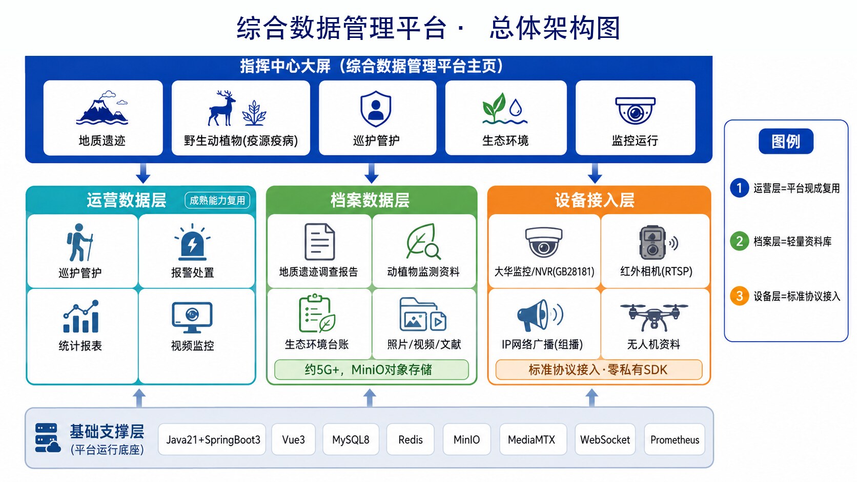
DEEP DIVE

Smart Nature-Reserve Patrol

SMART NATURE-RESERVE PATROL

Integrating existing surveillance, infrared, broadcasting, UAVs and multi-source survey data — from “isolated systems and paper-based patrols” to “one platform, visual command”, a digital-intelligence foundation that unifies patrol management and integrated data management for nature reserves.

01

CONTEXT

From “isolated systems and paper patrols” to “one platform, visual command”

Nature reserves accumulate years of multi-source data — geological heritage, biodiversity, ecological environment, patrol management and video surveillance — yet supervision commonly faces several challenges: surveillance, broadcasting, infrared and survey materials each sit in silos with no interconnection; historical reports, photos and videos are scattered and hard to search; patrols rely on paper records with no tracks or ledgers; alerts depend on staff watching screens, so handling lags; and legacy platforms have dated interfaces and lack unified display and integrated analysis — making it hard to support unified command-center control and scientific decisions.

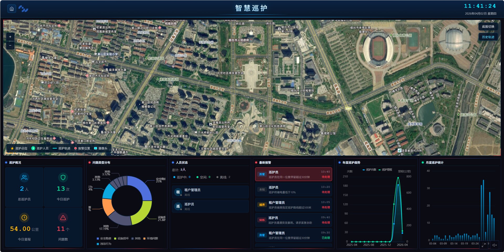
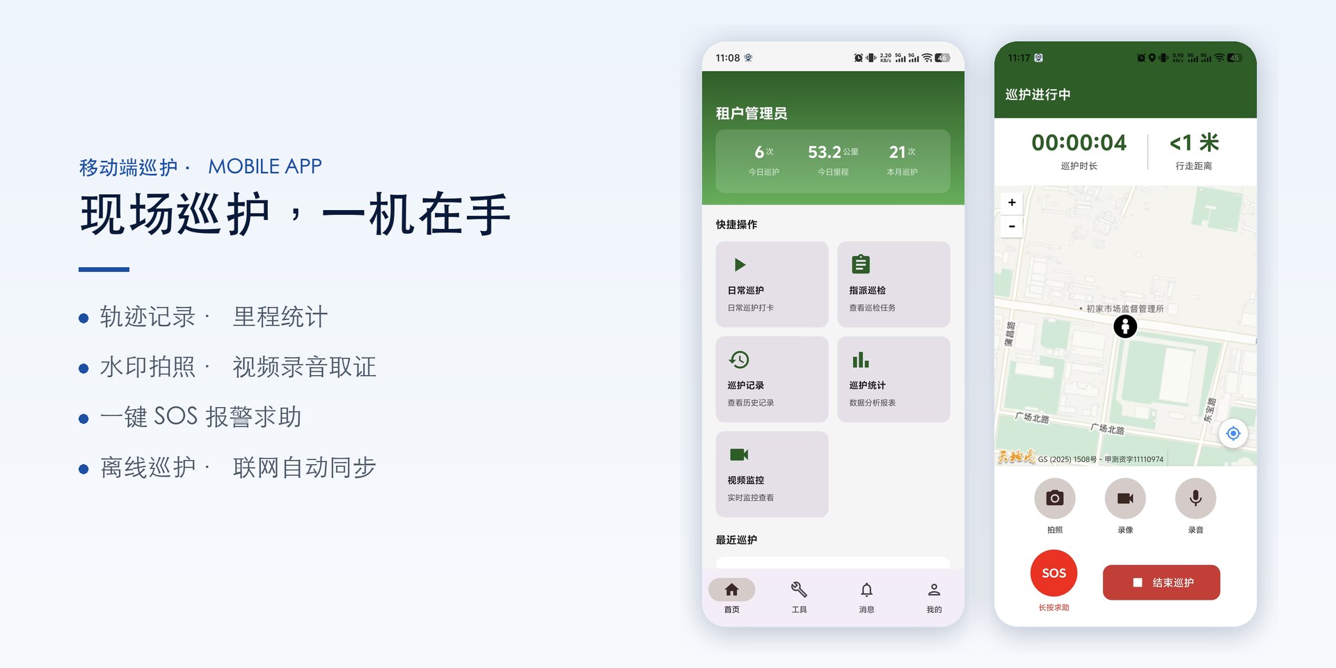
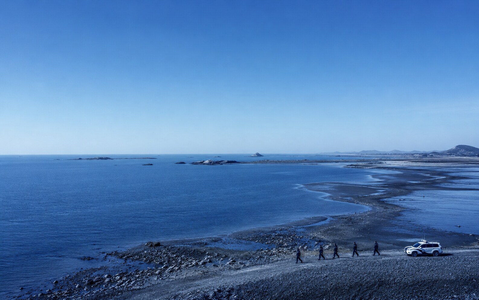
Building on the reserve’s existing platforms and device data, GW-OCEAN integrates video surveillance, IP broadcasting, infrared cameras, UAVs and other systems into one integrated data-management and smart-patrol platform that is digital, intelligent and three-dimensional: multi-source data is unified, the command dashboard presents it centrally, the full patrol process is managed visually, and data is stored locally for the long term and self-controlled — upgrading supervision from passive reaction to proactive perception and visual command.

02

ARCHITECTURE

Layered data hub + one patrol-management map

The solution is decoupled into four layers — device access, data fusion, intelligent applications, and interaction & display — and organized by data nature: the operational-data layer carries patrol management, alert handling, statistical reports and live video; the archive-data layer carries low-frequency reference material such as survey reports, photos and videos via a categorized repository plus object storage; the device-access layer connects existing cameras, NVRs, infrared cameras and IP speakers over GB28181 / RTSP / ONVIF / multicast standard protocols — no vendor-proprietary SDKs, with legacy equipment reused directly.

Overall architecture of the integrated data-management and smart-patrol platform for nature reserves (schematic)
Integrated data-management & smart-patrol platform · layered overall architecture (schematic)
A

Full-process patrol managementPatrol Management

A closed loop across patrol planning, task dispatch, track and mileage logging, real-time personnel status, issue evidence, standardized ledgers and monthly / annual statistical charts; the dispatch center assigns tasks in one click and can draw zones on the map to define patrol scope, with tracks auto-uploaded at patrol end for visual patrol management.

B

Mobile field operationsMobile App

A companion mobile app supports timing and track logging, GPS check-in and missed-patrol prompts, watermarked photos (overlaying time / coordinates / task / personnel), video and audio evidence, and one-tap SOS for help; offline patrol caches data without network and syncs automatically once connected, with offline maps usable in weak signal.

C

Video surveillance integrationVideo Integration

Existing cameras and NVRs connect over standard protocols, with unified streaming transcoded to HLS for Web and mobile playback; events at key points such as intrusion, tripwire and loitering trigger an alert pop-up + sound prompt + automatic recording, with the alert’s image and video pushed to the mobile end.

D

Multi-source device linkageDevice Linkage

Infrared-camera images and videos are retrieved on demand with tiered storage (auto-return retention and manual long-term retention both configurable); IP broadcasting plays warning and dispatch audio to the whole area or designated stations in one click; UAV aerial, multispectral and 3D-modeling results are archived for the long term and never auto-deleted.

E

Repository & integrated analysisData & Analytics

Survey reports, photos, videos and literature are categorized into the repository, with import / export / index / retrieval / deletion under permission control and logged; structured indicators extracted from monitoring reports are visualized on the dashboard, with year-on-year comparison and one-click Excel export of statistical reports.

F

Command-center dashboardCommand Dashboard

The command-center large screen presents the platform home page in a unified way, with each business board displayable together or individually under tiered menus; patrol-personnel locations, alert events and monitoring-point status refresh in real time (WebSocket push), in a government-grade deep-blue tech style with configurable title and branding.

Smart-patrol command-center dashboard (UI concept)
Command-center smart-patrol dashboard · UI concept
Mobile patrol operations (home and patrol-in-progress, UI concept)
Mobile patrol operations · home and patrol-in-progress
03

WORKFLOW

Sense — integrate — patrol — alert — archive, in a closed loop

  1. 1

    Multi-source sensing access

    Existing cameras, NVRs, infrared cameras, IP speakers and UAVs connect through unified access over GB28181 / RTSP / ONVIF / multicast standard protocols — no modification or replacement of legacy equipment.

  2. 2

    Unified data integration

    Video, alerts, infrared, broadcasting and multi-source survey materials are unified and governed; a categorized repository plus object storage carries the archives, and structured indicators feed dashboard visualization.

  3. 3

    Patrol task execution

    The dispatch center assigns tasks in one click and draws zones on the map to define scope; patrol staff accept tasks on the mobile app, log tracks and mileage, capture watermarked evidence, and auto-upload to the platform when patrols end.

  4. 4

    Linked alert handling

    Events at key points trigger an alert pop-up + sound prompt + automatic recording, with image and video pushed to the mobile end; patrol staff respond from nearby, capture and upload evidence, and handling progress is visible in real time.

  5. 5

    Ledger archiving & analysis

    Patrol, alert and rectification records are auto-aggregated into standardized ledgers, with year-on-year comparison and one-click export of monthly / annual statistical charts; data is retained locally for the long term and never auto-deleted.

04

ADVANTAGES

Why GW-OCEAN

Integrate what exists, protect investment

Built on existing platforms and device data: video surveillance, infrared, broadcasting and UAVs connect over standard protocols — no need to start over and no reliance on vendor-proprietary SDKs, with legacy equipment reused directly.

Visualized patrol closed loop

Plan — task — track — issue — alert — statistics — ledger form a full closed loop, with companion mobile field operations usable offline — upgrading paper patrols to visible, traceable and assessable.

Local data, self-controlled

Full-stack on-premises private deployment keeps data within the reserve, retained for the long term and never auto-deleted, with tiered permissions, operation auditing and SM cryptography — meeting nature-reserve data-security and long-term archiving requirements.

Integrated data, one-screen control

Multi-source data is unified and presented centrally on the command dashboard, with business boards displayable together or individually and year-on-year comparison — supporting unified command-center control and scientific decisions.

05

TYPICAL SCENARIO

Unauthorized intrusion into the core zone · linked alerting and mobile handling

Typical scenario of smart nature-reserve patrol (illustration) Smart Patrol · Scenario

At night, a sentry camera deployed at the core-zone boundary detects an intrusion / tripwire event — the command platform automatically pops up the alert with a sound prompt and records the point’s video, while the alert’s on-site image and video are instantly pushed to the nearest patrol officer’s mobile device.

The patrol officer reviews the alert footage and point coordinates on the mobile app, navigates to the scene, captures watermarked photos and video evidence and uploads them — the whole process auto-aggregated into a standardized ledger; the command center tracks personnel location, alert status and handling progress on one map in real time, and later closes the loop with the track and evidence records archived.

  • Key-point events alert automatically: pop-up + sound + recording + mobile push
  • Patrol staff respond from nearby, with watermarked evidence and tracks logged throughout
  • Alert — handling — ledger closed on one map, with data retained locally for the long term

Need a solution tailored to your sea area?

Whether marine ranching, smart fishing ports, aquaculture, or ocean observation and ecological monitoring, we’d be glad to explore it with you.